


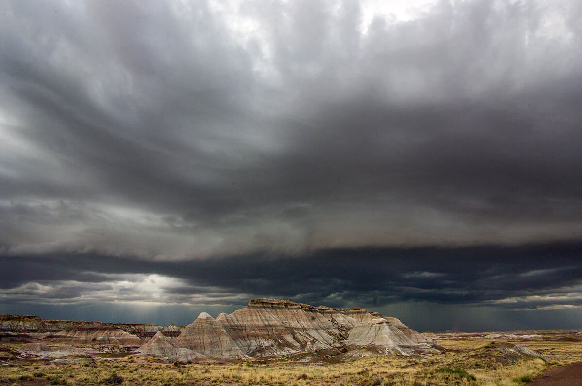
Although many of the most well-known monsoons are in Asia, the U.S. Southwest also regularly experiences monsoon season. This photo shows a storm during monsoon season in Petrified Forest National Park in Arizona. Credit: National Park Service/Stewart Holmes
When people think of a monsoon, they often think of heavy rains that pour down for weeks. While a rainy season is part of a monsoon, a monsoon is more than just rain. In fact, monsoons can also cause dry weather. Monsoons are caused by a change in the direction of the wind that happens when the seasons change. In fact, even the word monsoon comes from the Arabic word mausim, which means “season.”
What causes a monsoon?
A monsoon is caused by a seasonal shift in the winds. The winds shift because the temperature of the land and the temperature of the water are different as seasons change. For example, at the beginning of summer, the land warms up faster than bodies of water. Monsoon winds always blow from cold to warm. In the summer, warm air rising off the land creates conditions that reverse the direction of the wind.
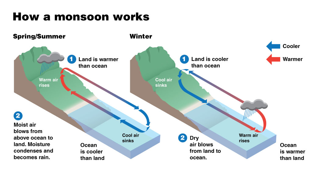
This diagram shows how seasonal temperature differences between the land and ocean can create the right conditions for a monsoon. Credit: NOAA/JPL
Why does a monsoon cause rain?
The monsoons that cause heaviest rainfall are summer monsoons near the Indian Ocean. Warm water in the ocean evaporates, rising into the air. This causes the wind to change direction and moisture blows toward the land in countries such as India and Sri Lanka. The warm, moist air then condenses and becomes rain. The result is a period of humidity and heavy rainfall that can last for months.
When the wind changes direction in the winter, it is called a winter monsoon. Winter monsoons in these regions near the Indian Ocean are usually dry.
Where do monsoons happen?
While many of the most well-known monsoons are in Asia, monsoons can happen anywhere there is a seasonal difference in temperature between the land and water. This is usually in tropical and subtropical climates.
The North American Monsoon is a seasonal change in wind that occurs as the summer sun heats the land of North America. During much of the year, the strongest winds over northwestern Mexico, Arizona and New Mexico are dry air blowing from the west.
As the land heats up in the summer, the wind begins to change direction and blows from the south. This new wind blows moist air from the Pacific Ocean and Gulf of California into the region, resulting in thunderstorms and rainfall.
In general, the North American Monsoon begins each year in Mexico in June. The winds blowing from the south move the monsoon to the U.S. Southwest in July. By mid-September, winds are once again blowing from the west, marking the end of the monsoon.
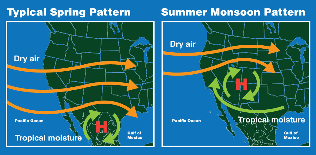
During typical conditions in the spring, the U.S. Southwest experiences strong, dry winds blowing from the west. During a summer monsoon, the region experiences winds from the south, which carry moisture from the Pacific Ocean and the Gulf of California. This can cause heavy rainfall and thunderstorms. Credit: NOAA/JPL
How do we watch monsoons from space?
With weather satellites, of course! Weather satellites, such as those in the GOES-R series are constantly keeping an eye on Earth’s weather. The GOES-16 satellite captured this imagery of a monsoon moving into the U.S. Southwest in August 2018.
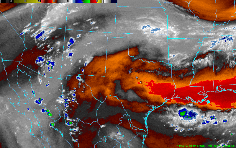
The GOES-16 weather satellite captured this imagery of water vapor moving into the U.S. Southwest in August 2018. This is a typical monsoon pattern for this region. Thunderstorms are represented by dark blue, green and red, while dry air is deep orange. Credit: NOAA
Monitoring monsoons in the U.S. Southwest is very important. More than 50% of the annual rain in Arizona and New Mexico falls during summer monsoon season, from July to September. Tracking the movement of a monsoon from space helps people down on Earth to plan for safety during storms, and also to anticipate the storm’s impact on their water supply.